
Ontario Highway 412 Summary
From Wikipedia, the free encyclopedia
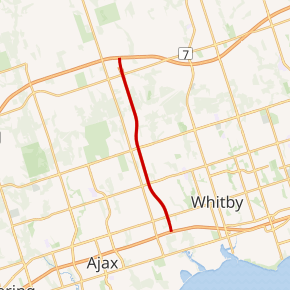
King's Highway 412, or simply Highway 412, is a tolled controlled-access highway in the Canadian province of Ontario. The route is 8.9 km (5.5 mi) long, connecting Highway 401 with the eastern extension of Highway 407. The route lies entirely within Whitby in the Regional Municipality of Durham, travelling within one kilometre of the border between Whitby and Ajax and Pickering (Lake Ridge Road).
During planning, the route was known as the West Durham Link. Its designation as Highway 412, the first new 400-series designation in several decades, was confirmed along with Highway 418 on February 6, 2015.
Although initially planned to open in October 2015, the opening was delayed until June 20, 2016. Highway 412 opened alongside the extension of Highway 407 (Highway 407E) from Brock Road in Pickering to Harmony Road in Oshawa. The Ministry of Transportation of Ontario (MTO) thus decided to compensate for delays by waiving all tolls until February 1, 2017....
ON-412 ON Exits
Highway ON-412 runs South to North with exit numbers starting at the southern most exit of each state or province.
Lodging Fuel Food Vehicle Shopping Entertainment/Tourist Medical Assistance Police Fire Pets Bank/ATM