
Interstate 10 in Louisiana
From Wikipedia, the free encyclopedia
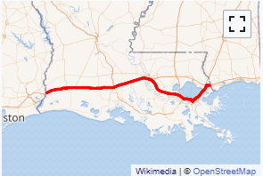
Interstate 10 (I-10), a major transcontinental Interstate Highway in the Southern United States, runs across the southern part of Louisiana for 274.42 miles (441.64 km). It passes through Lake Charles, Lafayette, and Baton Rouge before dipping south of Lake Pontchartrain to serve the New Orleans metropolitan area before leaving the state.
On August 29, 2005, the I-10 Twin Span Bridge was severely damaged by Hurricane Katrina, rendering it unusable. Initially, the bridge was repaired through a $30.9 million contract with Boh Brothers Construction Company. However, Louisiana has since replaced the bridge with two higher elevation spans in 2009 and 2010....
I-10 LA Exits
Highway I-10 runs West to East with exit numbers starting at the western most exit of each state or province.
Lodging Fuel Food Vehicle Shopping Entertainment/Tourist Medical Assistance Police Fire Pets Bank/ATM