
Interstate 2 Summary
From Wikipedia, the free encyclopedia
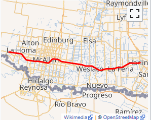
Interstate 2 (I-2) is a partially completed Interstate Highway running through the Lower Rio Grande Valley of South Texas. It begins at the intersection of U.S. Highway 83 (US 83) and Business U.S. Highway 83 (Bus. US 83) in Penitas and heads eastward before terminating at I-69E/US 77/US 83 in Harlingen. For its entire length, I-2 runs concurrently with US 83. I-2 also parallels Mexican Federal Highway 2 (Fed. 2), another major east\west route that traces the Mexico-U.S. border along the Mexican side of the Rio Grande. When completed, the western terminus will be the city of Laredo.
The route is one of the more recently designated interstate highways; it was signed as an interstate in 2013. Its construction is part of an expansion of the Interstate system into southern Texas that includes the three branches of Interstate 69 in Texas. It currently intersects I-69E and I-69C, and will, when complete to Laredo, intersect I-69W as well. As of 2019, this complex of Interstate highways does not yet connect to the rest of the system....
I-2 TX Exits
Highway I-2 runs West to East with exit numbers starting at the western most exit of each state or province.
Lodging Fuel Food Vehicle Shopping Entertainment/Tourist Medical Assistance Police Fire Pets Bank/ATM