
Interstate 20 in Texas
From Wikipedia, the free encyclopedia
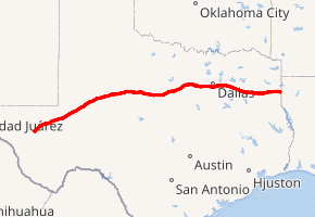
Interstate 20 in Texas (abbreviated I-20 or IH-20) is a major east\west Interstate Highway in the Southern United States, running east from a junction with Interstate 10 east of Kent, Texas, through the Dallas-Fort Worth Metroplex to the border with Louisiana near Waskom, Texas. The original distance of Interstate 20 was 647 miles (1,041 km) from I-10 to the Louisiana border, reduced to the current distance of 636 miles (1,024 km) with the rerouting of I-20 in the 1980s and 1990s. I-20 is known as the Ronald Reagan Memorial Highway within the Dallas-Fort Worth Metroplex....
Full Wikipedia TopicI-20 TX Exits
Highway I-20 runs West to East with exit numbers starting at the western most exit of each state or province.
Lodging Fuel Food Vehicle Shopping Entertainment/Tourist Medical Assistance Police Fire Pets Bank/ATM