
Interstate 44 in Texas
From Wikipedia, the free encyclopedia
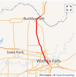
In the U.S. state of Texas, Interstate 44 (I-44) has a short but regionally important 14.77-mile (23.77 km) stretch, connecting Wichita Falls with Oklahoma. Its entire length is concurrent with U.S. Highway 277 and U.S. Highway 281. I-44 provides access to downtown Wichita Falls and Sheppard Air Force Base. Interstate 44 is known as Central Freeway in Wichita Falls and Red River Expressway in Burkburnett....
Full Wikipedia TopicI-44 TX Exits
Highway I-44 runs West to East with exit numbers starting at the western most exit of each state or province.
Lodging Fuel Food Vehicle Shopping Entertainment/Tourist Medical Assistance Police Fire Pets Bank/ATM