
Interstate 82
From Wikipedia, the free encyclopedia
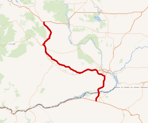
Interstate 82 (I-82) is an Interstate Highway in the Pacific Northwest region of the United States that travels through parts of Washington and Oregon. It runs 144 miles (232 km) from its northwestern terminus at I-90 in Ellensburg, Washington, to its southeastern terminus at I-84 in Hermiston, Oregon. The highway passes through Yakima and the Tri-Cities, and is also part of the link between Seattle and Boise, Idaho. I-82 travels concurrently with U.S. Route 97 (US 97) between Ellensburg and Union Gap; US 12 from Yakima to the Tri-Cities; and US 395 from Kennewick and Umatilla, Oregon.
I-82 primarily serves the Yakima Valley agricultural region, following the Yakima and Columbia rivers southeastward to the Tri-Cities. The highway enters the valley from the north by crossing the Manastash Ridge, which separates Yakima from the Kittitas Valley. I-82 bypasses the Tri-Cities by traveling southwest around Richland and Kennewick and then turns south to cross the Columbia River on the Umatilla Bridge. Its only auxiliary route, I-182, connects the highway to Richland and Pasco in the Tri-Cities.
The I-82 corridor was originally used by several state and national highways, including the Inland Empire Highway and US 410, which were built in the early 20th century. The federal government created I-82 in late 1957 to serve military facilities in the region, replacing an earlier designation for what is now I-84. The first section of I-82 to be constructed was the easterly bypass of Yakima, which opened in 1963 and was gradually extended north to Ellensburg by 1971. The Yakima Valley section, connecting Union Gap to Prosser, was constructed between 1977 and 1982.
The routing of the highway between Prosser and I-84 was very controversial among Tri-Cities residents, who lobbied for a longer I-82 alignment to serve them. Oregon legislators and highway officials remained opposed to a routing that bypassed Umatilla, leading to several attempts at finding a compromise along the Wallula Gap or in other areas southeast of the Tri-Cities. In 1973, Oregon and Washington adopted a federal compromise to build I-82 through Umatilla and around the outskirts of the Tri-Cities with a spur route (I-182) to serve the area directly. The Tri-Cities section opened in 1986 while in Oregon, the final section of I-82 was completed in 1988. In the early 2000s, Oregon highway officials examined plans to extend I-82 further south through eastern Oregon and towards California, but they were not considered for further study....
I-82 WA Exits
Highway I-82 runs West to East with exit numbers starting at the western most exit of each state or province.
Lodging Fuel Food Vehicle Shopping Entertainment/Tourist Medical Assistance Police Fire Pets Bank/ATM