
Interstate 90 Summary
From Wikipedia, the free encyclopedia
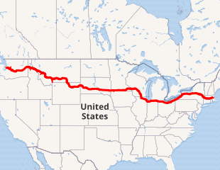
Interstate 90 (I-90) is an east\west transcontinental freeway, and the longest Interstate Highway in the United States at 3,020.54 miles (4,861.09 km). Its western terminus is in Seattle, at State Route 519 near T-Mobile Park and CenturyLink Field, and its eastern terminus is in Boston, at Route 1A near Logan International Airport.
The western portion of I-90 crosses the Continental Divide over Homestake Pass just east of Butte, Montana, connecting major cities such as Spokane, Washington; Billings, Montana; Sioux Falls, South Dakota; and Madison, Wisconsin.
Between Seattle and the Wisconsin-Illinois state line, I-90 is an Interstate without tolls. East of that border, much of I-90 follows several toll roads, many of which predate the Interstate Highway system. These include the Jane Addams Memorial Tollway, Chicago Skyway, Indiana Toll Road, Ohio Turnpike, New York State Thruway, and the Massachusetts Turnpike. The Interstate is not tolled through some segments in downtown Chicago; Greater Cleveland and the rest of Northeast Ohio; Erie and the rest of Northwestern Pennsylvania; and through brief sections near Buffalo and Albany....
I-90 States/Provinces
This highway passes through multiple states or provinces. Each is broken out sepeperatly in these listings.