From Wikipedia, the free encyclopedia
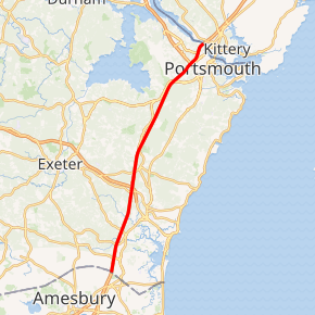
Interstate 95 (I-95), the main Interstate Highway on the east coast of the United States, cuts through the Seacoast Region of New Hampshire. The majority of it, from the Massachusetts border to the Portsmouth Circle in Portsmouth, is the 14.29-mile-long (23.00 km) Blue Star Turnpike or New Hampshire Turnpike, a toll road maintained by the New Hampshire Department of Transportation (NHDOT) Bureau of Turnpikes. The final piece in Portsmouth splits from the turnpike south of the circle, running 2.42 miles (3.89 km) to the Piscataqua River Bridge, a steel arch bridge, towards Maine and the Maine Turnpike. In its short length through New Hampshire, Interstate 95 traverses six municipalities: Seabrook, Hampton Falls, Hampton, North Hampton, Greenland, and Portsmouth....
Full Wikipedia TopicI-95 NH Exits
Highway I-95 runs South to North with exit numbers starting at the southern most exit of each state or province.
Lodging Fuel Food Vehicle Shopping Entertainment/Tourist Medical Assistance Police Fire Pets Bank/ATM
Portsmouth
Market Street / Woodbury Avenue - Downtown Portsmouth Exit 5
Portsmouth
US 1 Byp. (Portsmouth Circle),Spaulding Turnpike / US 4 / NH 16 - Newington, Dover, Durham, Concord Exit 3A
Portsmouth
Pease International Tradeport, Park & Ride, Bus Terminal Exit 1
Seabrook
NH 107 - Seabrook, Kingston
, Portsmouth
Market Street / Woodbury Avenue - Downtown Portsmouth Exit 5
, Portsmouth
US 1 Byp. (Portsmouth Circle),Spaulding Turnpike / US 4 / NH 16 - Newington, Dover, Durham, Concord Exit 3A
, Portsmouth
Pease International Tradeport, Park & Ride, Bus Terminal Exit 1
, Seabrook
NH 107 - Seabrook, Kingston
